Activities
Coastal Processes & Shoreline Management
Coastal Processes
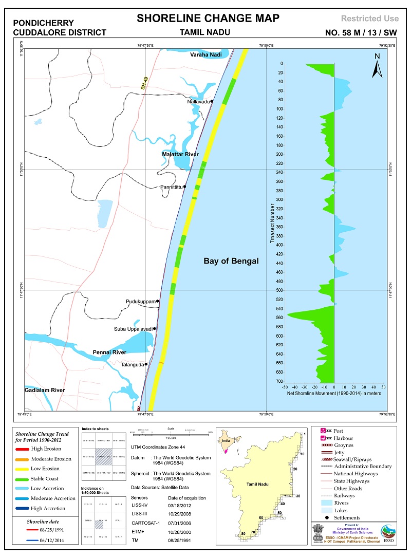
- Carried out shoreline change (long-term and short-term) analysis for Indian coast using 9 different data sets for the period of 28 years (1990-2018).
- Digital version of shoreline change maps for Indian coast in 1:25,000 scale is released
- National Assessment of shoreline changes along Indian Coast (1990 -2016) - Released in July 2018.
- National Shoreline Assessment System (N-SAS) for the period (1990-2018) - Released in March 2022.
- A report on Coastal Structures along Tamil Nadu and Puducherry Coast - Published.
- Detailed Shoreline Management Report for Chellanam coast, Ernakulam district, submitted to Irrigation Department, Government of Kerala.
- Project report on Protection of SHAR Island from Sea Erosion, submitted to Satish Dhawan Space Centre (SDSC)-SHAR.
- Detailed Project Report on Stabilisation of Raidoruvu Inlet, Pulicat Lake” submitted to Fisheries Department, Government of Andhra Pradesh.
- Trend Based models are developed to study the shoreline changes at Pilot locations of Chennai, Vishakhapatnam and Cuddalore.
- Carried out coastal processes studies at many coastal sectors along the Indian coast through extensive fieldwork and numerical modelling.
- Developed shoreline management plan (SMP) for selected location along Kerala coast (Panathura, Muthalapozhi, Vatanapally & Calicut), Karnataka coast (Netravati to Gurpur), Goa coast (Mandovi estuary), Maharashtra coast (Vengurla embayed beach) and Tamil Nadu coast (Mahabalipuram to Pulicat).
- Implemented two pilot groins at Panathura, by Kerala state government as part of suggestion given by NCCR by a project "Evaluation of structural and functional effectiveness of existing coastal protection structures along the Kerala coast". Beach developed in between groins and south side of groins due to this pilot groins.
- NCCR recommended offshore reef construction at Ullal, Karnataka for arresting erosion and construction work is in progress.
- Prepared tsunami inundation models for Indian coast to assess the extent of likely inundation due to various tsunamgenic sources of Indian Ocean.
- Developed integrated mathematical model for Gulf of Kachchh for disposal of dredged spills by ports, so that transportation of silt and their deposition on coral reef areas can be avoided.
- Developed Storm surge inundation models stimulated with past cyclones along the east coast of India.
- A status report of "Coastal erosion along Indian coast" prepared by NCCR in year 2009. The report was used to take a Policy decision by Ministry of Environment and Forest, New Delhi on moratorium of port development & New Port Policy vide O.B. No.15-3/2009-IA-III dated 3rd Nov 2009.